
SASGeo: Stability-Aware Semantic Map Localization for GNSS-Denied UAVs
A semantic map-localization framework for occasional absolute position fixes when visual-inertial odometry drifts and GNSS (Global Navigation Satellite System) is unavailable.
Abstract
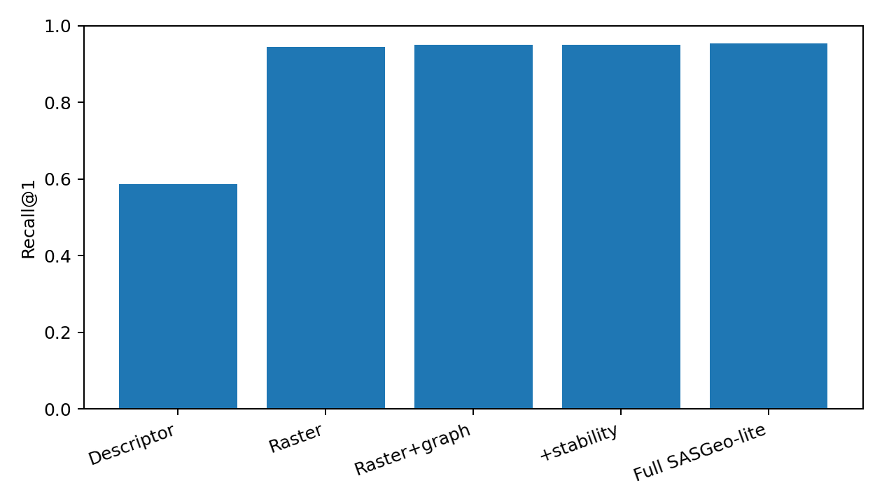
GNSS-denied UAVs need occasional absolute position fixes to bound visual-inertial drift. SASGeo replaces raw cross-view appearance matching with persistent semantic structure: roads, buildings, waterways, railways, intersections, and field boundaries. The framework combines raster alignment, relational graph evidence, stability and distinctiveness weighting, explicit unknown handling, and rejection of ambiguous fixes.
Semantic Map Intuition
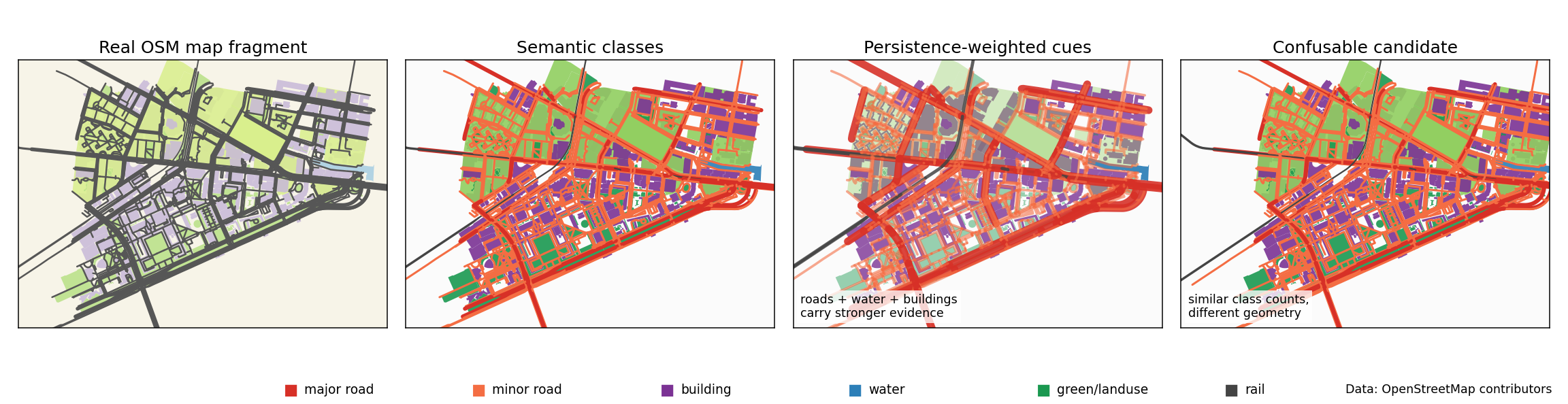
The main idea is simple: do not ask whether two places look the same in a photo. Ask whether the durable things on the ground are arranged the same way: roads, buildings, water, rail lines, and green areas.
Start with a normal map
Instead of using a camera photo, SASGeo starts from stable map objects: roads, buildings, water, rail, and green areas.
Turn objects into colors
Each kind of object gets its own color. This makes the map easier for an algorithm to compare than raw visual texture.
Trust stable shapes more
Long roads, intersections, waterways, and building layouts are stronger clues because they usually stay in the same place.
Reject look-alikes
A wrong place may contain the same amount of roads or buildings. SASGeo checks whether the arrangement matches too.
SASGeo Method
The framework is designed for cautious map fixes: match semantic geometry, verify relationships, and withhold corrections when evidence is weak or contradictory.
Semantic raster alignment
Match a local bird's-eye semantic observation against map layers instead of raw appearance.
Relational graph verification
Compare the arrangement of roads, buildings, waterways, intersections, and field boundaries.
Stability and distinctiveness
Give more weight to persistent, geographically informative structures and less to volatile cues.
Integrity-aware acceptance
Separate positive, contradictory, and unknown evidence, then reject ambiguous absolute fixes.
Build semantic BEV
Accumulate local observations into a compact semantic bird's-eye representation around the UAV.
Query map semantics
Render candidate map tiles into aligned semantic layers for roads, buildings, water, minor roads, and fields.
Score raster geometry
Search over rotation, scale, and crop perturbations with positive, contradictory, and unknown evidence.
Verify structure
Use graph and stability terms to check whether spatial relationships support the candidate location.
Accept or reject
Return an absolute correction only when score margin and consistency are strong enough for a cautious fix.
Synthetic Proof of Concept
This figure is a controlled toy test, not a real city map. It checks whether the method can solve the basic matching problem when the UAV view is incomplete, rotated, and partly wrong.
SASGeo receives a partial colored sketch of a place. It searches map candidates and asks: does this sketch fit here after rotation, or is this only a place with similar-looking pieces?
What the UAV sees
A small, damaged semantic view from the UAV. It is rotated and noisy, so only a few colored clues remain visible.
What can be trusted
The white mask says which parts of the view are known. Black areas mean missing or hidden data, not evidence against a place.
The correct answer
This is the map crop the query actually came from. A good matcher should find this one.
The tempting wrong answer
This candidate has similar colors and objects, but the roads and regions are arranged differently.
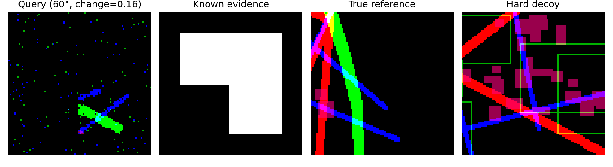
The black areas in the known-evidence panel mark missing or unobservable regions. SASGeo masks those regions instead of counting them as contradictions.
| Method | Recall@1 | MRR |
|---|---|---|
Global semantic descriptor Class-count baseline | 0.586 | 0.701 |
Raster, uniform weights Spatial semantics | 0.945 | 0.966 |
Raster + graph Relational check | 0.950 | 0.968 |
Raster + graph + stability Persistence weighting | 0.950 | 0.967 |
Full model + unknown handling Best synthetic result | 0.955 | 0.971 |
Integrity View
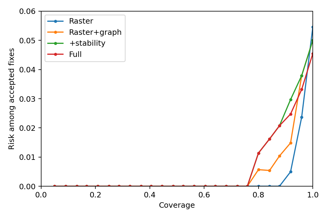
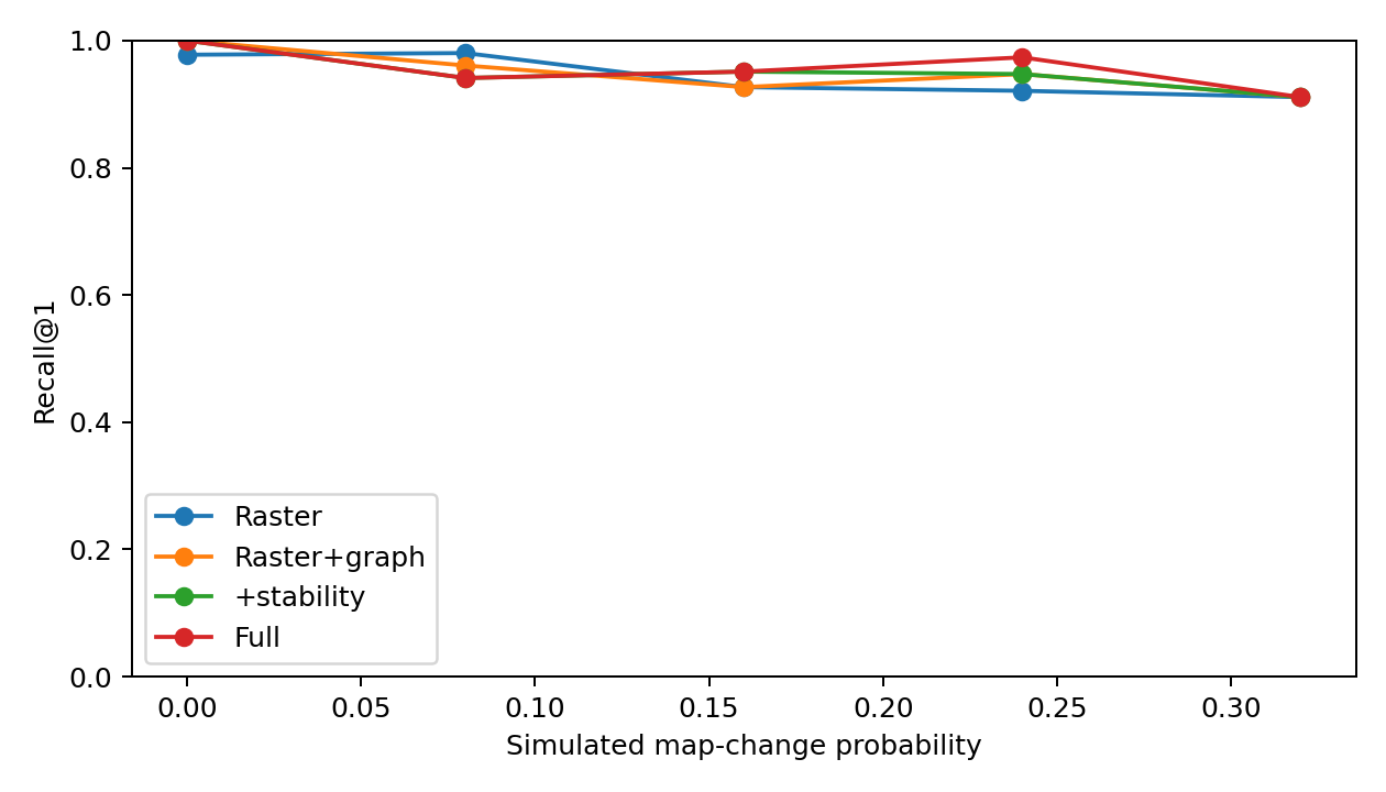
A navigation system should not always accept the top retrieval result. The experiment uses score margin as an uncalibrated rejection statistic and reports risk-coverage behavior for spatial ablations.
Full Trial Results
The released summary reports Wilson 95% intervals over 220 trials for each retrieval variant.
| Method | Recall@1 | 95% CI | Recall@5 | MRR |
|---|---|---|---|---|
| Global semantic descriptor | 0.586 | [0.520, 0.649] | 0.886 | 0.701 |
| Raster, uniform weights | 0.945 | [0.907, 0.969] | 1.000 | 0.966 |
| Raster + graph | 0.950 | [0.913, 0.972] | 0.995 | 0.968 |
| Raster + graph + stability | 0.950 | [0.913, 0.972] | 0.995 | 0.967 |
| Full model + unknown handling | 0.955 | [0.918, 0.975] | 1.000 | 0.971 |
Key Findings
Practical takeaways from the framework and released synthetic benchmark.
Semantic geometry is the main signal
Spatial semantic matching strongly outperforms a global descriptor under hard decoys, lifting Recall@1 from 58.6% to the 94.5-95.5% range.
Module-level gains need harder tests
Confidence intervals separate the global baseline from spatial methods, but overlap among graph, stability, and unknown-handling variants.
Rejection is part of localization
SASGeo treats a candidate pose as an integrity-sensitive fix: ambiguous matches should be withheld rather than forced into the state estimator.
The current result is not flight validation
The proof of concept starts from semantic layers and synthetic perturbations, leaving raw segmentation, VIO coupling, map age, and real UAV motion for follow-up.
Why semantic maps?
Raw appearance changes with season, illumination, viewpoint, sensor modality, and map age. Roads, intersections, waterways, railways, and building layouts are less fragile and can be compared against vector maps such as OpenStreetMap.
Reproducible prototype
Known Limitations
Synthetic semantic layers
The experiment begins after perception and does not measure segmentation or sensor-calibration errors.
Single-frame retrieval
Temporal filtering, repeated-frame consistency, and real VIO correction are specified as next evaluation steps.
Hand-set stability weights
Persistence and distinctiveness parameters need calibration from longitudinal geographic data.
Planar map model
The released experiment uses simplified maps, discrete rotations, and synthetic changes rather than full 3D environments.
Confidence intervals overlap
The study validates structured semantic geometry, not a definitive contribution from every proposed module.
Feature-poor regions remain hard
Forests, deserts, snow fields, open water, and repetitive grids can remain weakly observable or aliased.
References
Interested in this research?
We are open to collaborations on UAV localization, semantic maps, integrity-aware perception, and embedded autonomy.